Abstract
By using daily air temperature and precipitation data, and the weather phenomena data of daily snowfall from 98 meteorological stations over the Qinghai-Tibetan Plateau (QTP), this paper performs an “at-risk” evaluation on snowfall and accumulated snow over the QTP under current climate situation and future climate warming condition. When rainfall, snowfall, or accumulated snow weather phenomena occur, critical values are determined based on daily air temperature and precipitation for current climate conditions. Air temperature of 0°C is defined as the critical value of temperature for rainfall or snowfall, while 0°C air temperature and 4.0 mm (autumn) or 3.0 mm (spring) snowfall amounts are defined as the critical values for accumulated snowfall. Analyses based on the above critical values disclose that under current climate condition, stations with “at-risk” accumulated snow account for 33% and 36% of all stations, and the “at-risk” snowfall stations reach 78% and 81% in autumn and spring, respectively. Spatially, most stations with “at-risk” accumulated snow are located on the southern and eastern edge of the QTP, and stations with “at-risk” snowfall are also apparent at the northern edge. If the air temperature increases by 2.5°C in 2050, only the snowfall at a few “at-risk” snowfall stations will transform into rainfall, while most “at-risk” accumulated snow stations will face the problem that snowfall is hardly accumulated. Additionally, most stations will become “at-risk” accumulated snow stations, indicating that both the snow depth and the snow cover duration will decline in most areas of the QTP, including a delay of the start date and an advancing of the end date of snow cover.
Keywords
Qinghai-Tibetan Plateau ; snow cover ; at-risk ; snowfall ; vulnerability ; climate change
1. Introduction
Snow cover is one of the important components in the cryosphere. The Qinghai-Tibetan Plateau (QTP) is the largest snow-covered region in the mid-latitude of the Northern Hemisphere due to its elevated terrain. In accordance with global warming, the climate over the QTP shows a warming since the mid 1950s [ Liu and Chen, 2000 ]. Increased snow depth until the end of the 1990s and an enhanced amplitude of variation since the mid 1980s [ Ding, 2002 and Qin et al., 2006 ] may relate to changes in water vapor content of the regional atmosphere due to climate warming [ Qin et al., 2006 ]. However, the snow depth on the QTP was much lower than normal from the end of the 1990s until 2005 [ Ma , 2008 ]. The decrease in snow cover on the QTP is related to changing snowfall amounts and an acceleration of snow melting caused by increasing air temperature.
Snow cover not only plays an important role in adjusting the hydrologic cycle, and as a result, affects the seasonal distribution of water resources in arid and semi-arid regions, but also acts on the regional synoptic climate through affecting the surface energy balance. However, the previous studies mainly focused on the impact of climate warming on the snow cover extent, snow depth, and snow water equivalent, which took interest in snow parameters after the formation of snowpack, but ignored the impacts of climate warming on the formation of snow cover. Higher air temperature enables precipitation to fall more likely in liquid than in solid form, which will in turn reduce the snow amount. Further, higher air temperature usually makes snowfall much harder to accumulate, resulting in decreases in snow depth and in the number of snow cover days. Therefore, to assess the response of snow cover to climate warming, the vulnerability of snow cover in its formation phase will be evaluated.
The assessment of vulnerability is a process to define, quantify, and classify the vulnerability of a system. This study diagnoses the stations with “at-risk” snowfall (easy to transform into rainfall due to warmer climate) [ Nolin and Daly, 2006 ], and “at-risk” accumulated snow (hard to accumulate due to warmer climate) according to the actual situation of snow cover and climate over the QTP. Also, the possible changes of “at-risk” snowfall/accumulated snow stations are analyzed for the different warming levels in the future. Winter is the season with greater snow depth but less snowfall. Both the form of precipitation and the accumulation of snowfall over the QTP are hardly affected by increases in winter air temperature because they tend to be below 0°C even with significant warming. Autumn and spring are seasons of snowfall accumulation. The snow amounts in winter is largely determined by the accumulated snowfall amount in autumn, while snow amount in spring plays an important role on the thermal effect of underlying surface over the QTP. Therefore, the vulnerability of snow cover in its formation process in autumn and spring are investigated in this study.
2. Data and methodology
As we know, the data from remote sensing and reanalysis cannot accurately describe the characteristics of the underlying surface over the QTP due to its diverse relief, and the limited ability of the data sets in reflecting real situation [ Ma et al., 2008 ; 2009 ]. The ground-based observations obtained from direct reading of instruments are usually considered to be more objective and accurate. Hence, all data used in this study are ground-based observational data obtained from the National Meteorological Information Center (NMIC) of the China Meteorological Administration (CMA). Within the scope of the QTP (25°–40°N, 73°–105°E, above 2,000 m), there are 115 stations with data in selected parameters including air temperature, precipitation, and weather phenomena of snowfall and accumulated snow. To assess the vulnerability of snow cover at the stations, a representative 30-year time-period (1971–2000) is investigated in this research.
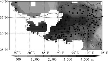
According to the seasonal characteristics of snow cover changes, a full snow year is determined to be from September until August of the next year. Each snow year begins with autumn and ends with summer. For example, we take the months of September, October, and November in the calendar year 1999 as the autumn of the snow year 2000, and take December in the calendar year 1999, January and February in the calendar year 2000 as the winter of the snow year 2000, and so forth. Based on this, monthly data are converted into seasonal and annual scale. When missing values appear in any month of a season or year, it is marked as missing value correspondingly. Stations with missing values in more than 15 years during 1971–2000 are excluded in order to ensure the reliability of data. As a result, 98 stations distributed over the QTP are left for this study (Fig. 1 ). When computing regional averages, it is marked as missing when missing values occur in more than half of the stations in the corresponding region. Note that the stations are mainly located in the mid-eastern part of the QTP, and hence, this research reflects mostly the situation in the middle and eastern regions.
|
|
|
Figure 1. Distribution of 98 meteorological stations (solid circles) over the QTP used in this study (the shaded background shows the stations’ elevation) |
In the initial stage of formation, snow cover is easily affected by both air temperature and water vapor content, that is, “at-risk” snowfall or accumulated snow is actually easy to occur when the weather condition is warmer and wetter, i.e., in maritime climate. According to the snow classification of Sturm et al. [1995] , maritime snow was defined as the snow falling in relatively warmer (0°C) and wetter (daily snowfall amount > 2 mm) climate, and was termed as “at-risk” snow by Nolin and Daly [2006] , which is most sensitive to air temperature. Therefore, to determine whether it is “at-risk” snow, the weather condition in the initial stage of snowfall or accumulated snow formation, i.e., the climatic critical values, should be investigated. The stations that meet the critical values are those with “at-risk” snowfall or accumulated snow. Both critical values of air temperature and precipitation are determined respectively for rainfall, snowfall, or accumulated snow. The following three weather phenomena are analyzed: 1) With rainfall and without snowfall phenomena (RP); 2) with snowfall and without snow accumulation phenomena (SP); 3) with both snowfall and snow accumulation phenomena (AP). The daily snowfall amounts used in this study are calculated from daily snowfall weather phenomenon and daily precipitation data via the following methods. If the weather phenomenon of snowfall was recorded for a day, the corresponding amount of precipitation is taken as snowfall amount for the same day. If no snowfall phenomenon was recorded for a day, the snowfall amount is set to zero for this day. If the snowfall phenomenon was recorded as missing, the snowfall amount is also set to missing. Based on this, the day is marked as RP if the precipitation amount was not equal to zero and no snowfall phenomenon occurred. If the snowfall amount was not equal to zero but no phenomenon of accumulated snow occurred, SP is marked for the day. Similarly, if snowfall amount was not equal to zero and the accumulated snow phenomenon was recorded, AP is marked for this day. Following this, the corresponding critical values are analyzed for the three phenomena mentioned above, and the statuses of snowfall and accumulated snow at the stations are determined.
Moreover, it is projected that the air temperature over the QTP will possibly increase by 2.2–2.6°C until 2050 [ Qin , 2002 ], which will result in changes in the degree of vulnerability of snowfall and accumulated snow. Therefore it is important to evaluate these changes. However, although the Fourth Assessment Report (AR4) of the Intergovernmental Panel on Climate Change (IPCC) published the situation of global warming under a variety of greenhouse gases emission scenarios, it is difficult to project the changes of air temperature for every ten years at regional scale, especially over regions like the QTP with relative small scope and complicated terrain. Also, because of the uncertainties in projecting precipitation in multiple models, we do not consider its possible impact on the changes of “at-risk” snow. Therefore, this study investigates the responses of “at-risk” snow in different regions by grading the warming by a 0.5°C interval each time.
3. Results
3.1. Determination of critical values of air temperature and precipitation
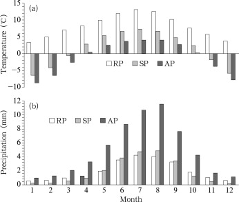
Although the critical values for “at-risk” snow were successfully applied in the Rocky Mountains of North America [ Nolin and Daly, 2006 ], the critical values for the QTP need to be defined anew, due to its different climatology and topography. First, we calculate the daily air temperature and precipitation when RP, SP, and AP occurred for all stations of the QTP during 1971–2000, respectively. Figure 2 shows the corresponding monthly variations of mean daily air temperature and precipitation over the QTP. Obviously, the required air temperatures decrease gradually when RP, SP, and AP occur (Fig. 2 a). Generally, SP can occur below 7.3°C, but the air temperature won’t exceed 4.0°C when AP occurs. On the contrary, the required precipitation amounts increase gradually (Fig. 2 b). RP occurs only above 0°C, and has nothing to do with the precipitation amount. No matter above or below 0°C for air temperature, SP and AP occurred in all months (Fig. 2 a). If air temperature is higher, more precipitation is needed for SP. If air temperature is equal to or below 0°C, less precipitation is needed for SP. For example, there is SP in March with −0.6°C air temperature and 0.5 mm precipitation amount. This indicates that rainfall or snowfall is not closely related to the water vapor content in the air, but determined mainly by the air temperature. Therefore, the critical air temperature is defined as 0°C to determine rainfall or snowfall. The snowfall occurring above 0°C is unstable and may transform into rainfall when affected by climate warming, and hence is termed as “at-risk” snowfall.
|
|
|
Figure 2. Monthly variations of mean daily (a) air temperature and (b) precipitation when RP, SP, and AP occur over the QTP during 1971–2000 |
The critical air temperature and precipitation for SP and AP were further determined. As seen from Figure 2 a, SP may occur in any condition of air temperature for all months. It is notable that the snowfall amounts are less in winter with air temperature below 0°C, and are relatively more in summer with air temperature above 0°C. This indicates that snowfall amount is determined mainly by the water vapor content in the air, but not by the air temperature. It coincides with the climatic characteristics of the QTP, which are drier in winter and wetter in summer due to the monsoon climate. Moreover, AP also occurs in any condition of air temperatures for all months, while more snowfall is needed for accumulation if higher air temperatures exist. As seen from Figure 2 a, the air temperatures for SP are below 0°C from November to March, which means the snowfall does not accumulate below 0°C. The possible reason is that the corresponding snowfall amounts are generally less than 0.5 mm (Fig. 2 b). Similarly, the snowfall accumulates from April to October when the air temperatures are above 0°C due to much more snowfall amounts (Fig. 2 b). In autumn and spring, the mean air temperatures are both below 0°C in November and March, and both above 0°C in October and April, but the corresponding required snowfall amounts are different for accumulation. In November/March, the snowfall does not accumulate when the amount is 0.4 mm/0.5 mm, but accumulates when it is 1.6 mm/2.0 mm. In October/April, the corresponding snowfall amounts are 4.2 mm/3.2 mm for AP, but are only 1.2 mm/0.1 mm for SP. This indicates that the snowfall may accumulate when reaching a certain amount no matter if the air temperature is above or below 0°C.
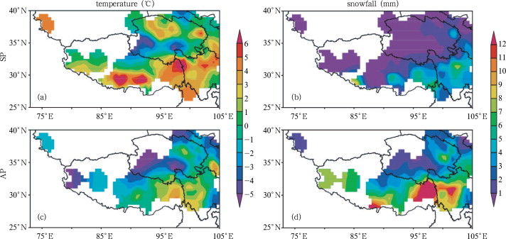
In addition to the situation for the QTP as a whole, a spatial analysis is performed to further determine the critical values. Figure 3 shows the air temperatures and snowfall amounts when SP and AP occur in autumn. As shown in Figure 3 a, even if the air temperatures are below 0°C, SP occurs in most of the central and northern QTP. Correspondingly, the snowfall amounts in that region are usually less than 1.0 mm (Fig. 3 b). That is, in autumn, no matter how low the air temperatures are, the snowfall won’t accumulate if the amounts are little, which is possibly due to the high wind speed. However, the snowfall may accumulate even if the air temperatures are above 0°C, such as in parts of the southeastern and eastern QTP shown in Figure 3 c. The corresponding snowfall amounts are generally more than 4.0 mm (Fig. 3 d). That is, no matter how high the air temperatures are in autumn, the snowfall may accumulate as long as the amounts are enough. In spring (not shown), the corresponding snowfall amounts are 1.0 mm for SP and 3.0 mm for AP with air temperature below and above 0°C, respectively.
|
|
|
Figure 3. Spatial distribution of mean daily air temperature (a, c), and snowfall amount (b, d) when SP (a, b) and AP (c, d) occur over the QTP during 1971–2000 |
In short, although snowfall will accumulate when the amount is greater than 4.0 mm/3.0 mm in autumn/spring even with higher air temperatures, it is unstable and easily affected by increasing air temperatures. Therefore, we define 0°C and 4.0 mm/3.0 mm as the critical air temperature and precipitation amounts for accumulation of snowfall in autumn/spring. Occurring snowfall at above 0°C and with daily amounts above 4.0 mm/3.0 mm in autumn/spring is called “at-risk” accumulated snow.
3.2. Distribution of stations with “at-risk” snow
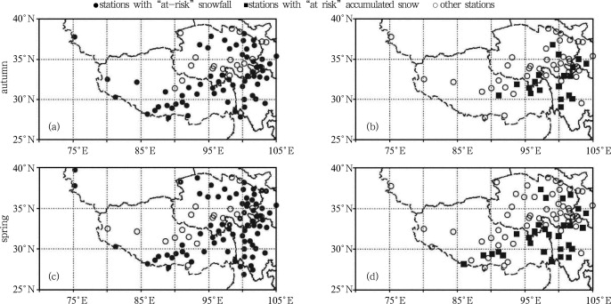
The vulnerability of snowfall and accumulated snow is examined for each station based on their corresponding critical value described above. Figure 4 shows the spatial distribution of stations with “at-risk” snowfall and accumulated snow in autumn and spring, respectively. The stations with “at-risk” snowfall are mainly located at the outer and northern regions of the QTP in both autumn and spring. While the stations with “at-risk” accumulated snow are mainly located in the eastern and southern regions of the QTP. The proportion of stations with “at-risk” snowfall to all stations over the QTP is 78% and 81% for autumn and spring, while it is 33% and 36% with “at-risk” accumulated snow, respectively. That is, the proportion of solid precipitation to total precipitation will possibly decrease at around 80% of all the stations due to continuing climate warming. At the same time, the proportion of accumulated snow to the solid precipitation will possibly decrease at around 35% of all stations.
|
|
|
Figure 4. Spatial distribution of stations with “at-risk” snowfall (a, c, solid circle) and “at-risk” accumulated snow (b, d, solid square) over the QTP in autumn (a, b) and spring (c, d), 1971–2000 |
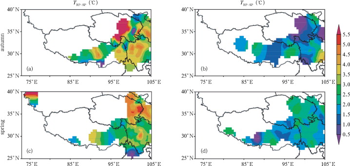
Clearly, there exists a distinct regionality of “at-risk” snow over the QTP. The changes in vulnerability will possibly be different for different phases of climate warming. By applying projections of a 2.2–2.6°C warming by 2050, mentioned in section 2 , the changes of vulnerability for all stations are examined. Figure 5 shows the spatial distribution of differences in air temperature between RP and SP and between SP and AP in autumn and spring, respectively, in which every 0.5°C difference was marked in different color. As mentioned above, although the air temperatures at many stations are above 0°C when SP occurs (Fig. 3 a), they are much higher when RP occurs. Therefore, by calculating the air temperature difference between RP and SP for each station, we can determine what the air temperature gap is for precipitation falling in a solid or liquid state. As seen from Figure 5 , the required warming discrepancies are obvious in different regions for “at-risk” snow. At regions, where the air temperature differences are below 2.5°C (Fig. 5 a, 5 c) “at-risk” snowfall will possibly transform into rainfall (SP to RP, S-R in short) in autumn and spring, respectively. Similarly, snowfall at “at-risk” accumulated snow stations in Figure 5 b and 5 d may not accumulate any longer (AP to SP, A-S in short) due to climate warming in the next 50 years. Obviously, in both seasons (autumn or spring) the areas with A-S will be much wider than with S-R.
|
|
|
Figure 5. Spatial distribution of the mean daily air temperature differences between RP and SP (a, c), and between SP and AP (b, d) over the QTP in autumn (a, b) and spring (c, d), 1971–2000 |
According to statistics, there are only ten stations with S-R distributed in the central, southeastern, and northeastern QTP in autumn (Fig. 5 a). In spring, some stations are also distributed in the Sichuan province and in parts of northern Yunnan province (Fig. 5 c). This is consistent with the distribution of regions with less snowfall when higher temperature at 500 hPa exist [ Ma , 2008 ], disclosing the sensitivity of snowfall to temperature. Although there are not so many stations which show a transformation of the precipitation state in the future, it will be more difficult for snowfall to accumulate under general warmer conditions. In autumn (Fig. 5 b), when the air temperature increases by 1.0°C, the A-S region is mainly located at parts of the eastern Qinghai, southern Gansu, and southwestern Sichuan provinces. When the air temperature increases by 2.0°C, the snowfall at most stations will hardly accumulate. The situation in spring (Fig. 5 d) is not so severe. The A-S region is mainly located in the eastern and southern QTP when the air temperature increases by 2.0°C, and will expand to most of the stations when air temperature increases by 2.5°C.
In short, the area with “at-risk” snow over the QTP will increase due to climate warming. This indicates that the increasing air temperature has influenced and will influence the formation of snow cover over the QTP. As a result, the shrinkage of snow depth and the shortening of snow cover duration including the delay/advance of snow cover start/end date can be expected correspondingly.
4. Conclusions and discussion
Based on observed daily data from NMIC/CMA, this study determines the critical air temperature and precipitation amounts for “at-risk” snowfall and accumulated snow in autumn and spring, and then diagnoses the current stability and possible near-term changes of snow cover over the QTP. According to the actual situation over the QTP, air temperature of 0°C is taken as the critical value for rainfall or snowfall in both autumn and spring. Both 0°C air temperature and 4.0 mm/3.0 mm snowfall amount are taken as the critical values for snow accumulation in autumn/spring. The statistical results show that the proportion of stations with “at-risk” accumulated snow to all stations over the QTP is more than 30%, mainly distributed in the southern and eastern QTP. Around 80% of all stations suffer “at-risk” snowfall, and except for the regions mentioned above, some stations lie in parts of the northern QTP. It is much easier for an increasing air temperature to affect the state of precipitation than the accumulation of snowfall because the latter requires much lower air temperature. Moreover, the distribution of “at-risk” snow also illustrates that the snow conditions at the edge of the QTP are more sensitive to climate warming than the conditions in the center.
When the air temperature increases by 2.5°C in the middle of the 21st century, some stations with “at-risk” snowfall will be affected by a transformation of snowfall to rainfall. The problem that snowfall may not accumulate shouldn’t be neglected any longer. The research indicates that most of the stations with “at-risk” accumulated snow over the QTP, no matter in autumn or spring, will be affected by a 2.5°C warming. This implies a possible thinning of snow depth and delay/advance of snow cover start/end dates. Analyses based on observational data over the QTP indicated that snow depth was much lower than normal from the late 1990s until 2009 [ Ma , 2008 ], which is to some degree attributed to the decreasing probability of snowfall and accumulated snow. However, it should be noted that this study did not consider possible changes of precipitation caused by climate warming due to great uncertainties.
The QTP is the headstream of many important rivers in China, and snow cover is a main basis for seasonal water resources. Changes of snow cover in seasons of snow accumulation and melting should be paid more attention. Less accumulation of snowfall in spring will increase the river flow directly and even bring spring floods. Similarly, less accumulation of snowfall in autumn will delay the snow cover start date and reduce the snow depth, and hence affect the buildup of seasonal frozen ground and the energy balance of the earth-atmosphere system. These changes will be destined to affect the livelihood of human beings. Therefore, the existence and possible development of “at-risk” snow over the QTP should not be ignored.
Acknowledgements
This study was partly supported by the opening fund from the State Key Laboratory of Cryospheric Sciences, Cold and Arid Regions Environmental and Engineering Research Institute, Chinese Academy of Sciences (SKLCS 08-07) and the National Postdoctoral Scientific Foundation (20080440342).
References
- Ding, 2002 Y. Ding; D. Qin (Ed.), Forecast in Environment Changes in Western China. Assessment on the Environmental Evolution in Western China (in Chinese), Science Press (2002), p. 239
- Liu and Chen, 2000 X. Liu, B. Chen; Climatic warming in the Tibetan Plateau during recent decades; International Journal of Climatology, 20 (14) (2000), pp. 1729–1742
- Ma, 2008 L. Ma; The Temporal and Spatial Characteristics of Snow Depth over the Qinghai-Tibetan Plateau in the Recent 50 Years and Its Relationship with Factors of Atmospheric Circulation (in Chinese) ; Chinese Academy of Meteorological Sciences/Graduate University of Chinese Academy of Sciences (2008), p. 156
- Ma et al., 2009 L. Ma, T. Zhang, W.O. Frauenfeld, et al.; Evaluation of precipitation from the ERA-40, NCEP-1, and NCEP-2 reanalyses and CMAP-1, CMAP-2, and GPCP-2 with ground-based measurements in China; J. Geophys. Res., 114 (D09105) (2009) http://dx.doi.org/10.1029/2008JD011178
- Ma et al., 2008 L. Ma, T. Zhang, Q. Li, et al.; Evaluation of ERA-40, NCEP-1, NCEP-2 reanalysis air temperature with ground-based measurements in China; J. Geophys. Res, 113 (D15115) (2008) http://dx.doi.org/10.1029/2007JD009549
- Nolin and Daly, 2006 W.A. Nolin, C. Daly; Mapping “at-risk” snow in the Pacific northwest; J. Hydrometeorology, 7 (5) (2006), pp. 1164–1171 http://dx.doi.org/10.1175/JHM543.1
- Qin, 2002 D. Qin; D. Qin (Ed.), Synthetical Report of the Assessment on the Environmental Evolution in Western China. Assessment on the Environmental Evolution in Western China (in Chinese), Science Press (2002), p. 80
- Qin et al., 2006 D. Qin, S. Liu, P. Li; Snow cover distribution, variability and response to climate change in western China; J. Climate, 19 (2006), pp. 1820–1833 http://dx.doi.org/10.1175/JCLI3694.1
- Sturm et al., 1995 M. Sturm, J. Holmgren, G.E. Liston; A seasonal snow cover classification-system for local to global applications; J. Climate, 8 (5) (1995), pp. 1261–1283 http://dx.doi.org/10.1175/1520-0442(1995)008 < 1261:ASSCCS > 2.0.CO;2.
Document information
Published on 15/05/17
Submitted on 15/05/17
Licence: Other
Share this document
Keywords
claim authorship
Are you one of the authors of this document?
