Abstract
The present study focused on statistical analysis of interannual, interdecadal variations of climate variables and extreme climate events during the period of 1961–2010 using observational data from 376 meteorological stations uniformly distributed across Southwest China, which includes Yunnan, Guizhou, Chongqing, Sichuan and Tibet. It was found that temperatures in most of the region were warming and this was especially evident for areas at high elevation. The warming was mostly attributable to the increase in annual mean minimum temperature. The characteristics of high temperature/heat waves are increase in frequency, prolonged duration, and weakened intensity. Annual precipitation showed a weak decreasing trend and drier in the east and more rainfall in the west. The precipitation amount in flood season was declining markedly in the whole region; rainfall from extreme heavy precipitation did not change much, and the portion of annual precipitation contributed by extreme heavy precipitation had an increasing trend; annual non-rainy days and the longest consecutive non-rainy days were both increasing; the extreme drought had a decreasing trend since the 1990s; the autumn-rain days displayed a downward fluctuation with apparent periodicity and intermittency. The number of southwestern vortices was decreasing whereas the number of moving vortices increased.
Citation
Ma, Z.-F., J. Liu, S.-Q. Zhang, et al., 2013: Observed climate changes in Southwest China during 1961–2010. Adv. Clim. Change Res.,4 (1), doi: 10.3724/SP.J.1248.2013.030.
Keywords
climate change ; Southwest China ; extreme climate events
1. Introduction
The global climate has undergone a significant change characterized by the warming of surface air temperatures in the last 100 years or so [ IPCC, 2007 ]. Within China, the climate has changed basically in tune with this trend [ ECSCNARCC, 2011 ]. Extreme climate events such as high temperature, drought, storms, and flood occurred frequently and caused large hazards and exerted profound impacts on human society and natural environment. For example, over the past 50 years, extreme precipitation events in the Northern Hemisphere has increased; intensity and frequencies of extreme precipitation events in China have increased [ Zhai and Pan, 2003 , Liu et al., 2006 and Wang and Zhai, 2008 ].
Southwest China possesses complex topographies, which include the Yunnan-Guizhou Plateau, the Qinghai-Tibet Plateau, the Hengduan Mountains, and the Sichuan Basin. As a result, local climate change has significant regional characteristics due to the impact of local topographies. Previous studies revealed that the long-term trend of temperature in Southwest China was not necessarily in tune with global warming. Ding and Dai [1994] found that during 1951–1990 the Southwest China experienced a persistent cooling; Ma et al. [2006] , using observed data for 1961–2000 from 139 meteorological stations in Southwest China, discovered that abrupt temperature change in Southwest China was later than that of the global temperature, and the abrupt change in higher altitude was earlier than that in lower altitude (in the basin and over the hills). Compared to the previous 40 years, there has been a significant increase in extreme drought and flood events in Southwest China since the start of the 21st century [ Duan et al., 2000 ; Hu et al., 2006 ; Huang , 2011 ].
In this study, we will document the changes in several meteorological elements in the last 50 years. Compared to previous studies, more observed surface data will be used in this study and several extreme climate events will be analyzed and discussed to provide important information for climate change communities and policy-makers.
2. Data and method
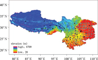
The present paper uses observed daily precipitation, mean temperature, maximum temperature, minimum temperature, and monthly foggy days for 1961–2010 from 376 meteorological stations in Southwest China which have continuous records (Fig. 1 ). All data were screened following quality control procedures of Southwestern Regional Center for Climate Change. For evenly distributed stations and taking into account of the influence of geography and topography, a few missing observations were first interpolated by using average of the prior and next years’ observed values. Then, tests of SNHT, TPR, Buishand, Pettitt and Von Neumann were used to correct data and conduct homogeneity test [ Alexandersson and Moberg, 1997 and Andrew, 1987 ; Lund and Reeves, 1999; Slonosky et al., 1999 and Wijngaard et al., 2003 ] to avoid the impact of relocation of some stations. The t -test is used to examine the significance at a confidence level of 95% for linear trend.
|
|
|
Figure 1. Stations in Southwest China (circle denotes homogeneous stations; solid dot denotes inhomogeneous stations) |
The four seasons are defined as last December to February for winter, March to May for spring, June to August for summer, and September to November for autumn, respectively. The flood season refers to June to August. The definitions of climate events are given in Table 1 .
| Climate event | Definition |
|---|---|
| Annual temperature range | The difference between the maximum monthly mean temperature and minimum monthly mean temperature |
| Hot (cold) day | A hot day refers to daily maximum temperature ≥ 35°C, and a cold day refers to daily minimum temperature ≤ 5°C or ≤ 0°C |
| Heat wave | Maximum daily temperature ≥ 35°C and daily mean temperature ≥ 25°C for 3 days; the intensity of a heat wave is the daily mean temperature during the event |
| Extreme maximum temperature | The maximum of daily maximum temperature throughout the year |
| Extreme minimum temperature | The minimum of daily minimum temperature throughout the year |
| Rainy day | Daily precipitation > 0.1 mm |
| Rain intensity | The ratio of total precipitation and rainy days |
| Rainstorm | Daily precipitation ≥ 50.0 mm |
| Extreme heavy precipitation | Daily precipitation greater than or equal to the threshold which is determined as the 95 percentile of daily precipitations in 1971—2000 listed in ascending order |
| Extreme precipitation intensity | The ratio of extreme heavy precipitation amount to extreme heavy precipitation days |
| Extreme heavy precipitation percentage | The ratio of extreme heavy precipitation amount to annual total precipitation |
| Extreme light precipitation | Daily precipitation ≥ 0.1 mm and < 1.0 mm |
3. Temperature
3.1. Mean temperature
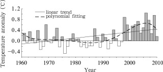
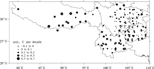
During 1961–2010, annual mean temperature in Southwest China showed a statistically significant increasing trend of 0.12°C per decade (Fig. 2 ). This increasing rate was lower than the same period national rate of 0.22°C per decade [ ECSCNARCC, 2007 ]. The rising temperature in this region was mainly due to the warming started in the mid-1990s; since then the temperature in most areas had shown a significant upward trend (Fig. 3 ); temperatures in northern and western Tibet had exhibited most significant increasing (at a rate of 0.4–0.5°C per decade). For seasonal mean temperatures, the most distinguished upward trend occurred in winter, followed by autumn, whereas spring and summer did not show a significant increasing trend (Table 2 ). In terms of spatial distribution, in all seasons the temperature increasing rate in Tibet and western Sichuan Plateau was greater than the other regions. In summer a cooling trend was seen in Chongqing, northeastern Sichuan Basin and northeastern Guizhou; all other areas showed a warming trend.
|
|
|
Figure 2. Variations of annual mean temperature in Southwest China during 1961–2010 |
|
|
|
Figure 3. Spatial distribution of linear trends in annual mean temperature in Southwest China during 1961–2010 (cross denotes the trend significant at the 95% confidence level) |
| Project | Linear trend |
|---|---|
| Annual | 0.12* |
| Winter | 0.21* |
| Spring | 0.07 |
| Summer | 0.05 |
| Autumn | 0.16* |
Note:
- . denotes the trend significant at the 95% confidence level
In Southwest China, the most significant warming during 1961–2010 was in winter season. The warming trend was mostly contributed by the increasing since the 1990s. The magnitude of warming increased with altitude, and the most distinguished upward trend occurred in the Qinghai-Tibet Plateau.
3.2. Extreme temperatures
During 1961–2010, the annual mean minimum and maximum temperatures both exhibit significant increasing trends with rates of 0.17°C per decade and 0.21°C per decade respectively. Within the same period of time, the extreme minimum temperature showed a significant increasing trend at a rate of 0.30°C per decade, and the extreme maximum temperature exhibited a weak increasing trend (0.06°C per decade). With regard to spatial distribution, extreme maximum temperature increased in the northern part but decreased in the southwestern part of the region. However, extreme minimum temperature increased throughout the entire region. Because the increasing rate of minimum temperature was higher than that of maximum temperature, annual temperature range decreased at the rate of –0.20°C per decade.
The change in extreme maximum and minimum temperatures was asymmetric, which is consistent with the conclusion that on the national scale extreme minimum temperatures increased markedly but extreme maximum temperatures increased insignificantly [ Ren et al., 2005 , Tang et al., 2005 , Xie and Cao, 1996 and Jiang and Ding, 1999 ].
The number of cold days for category ≤ 5°C exhibited significant decreasing trend at a rate of –2.0 d per decade, and for category ≤ 0°C at –0.8 d per decade during 1961–2010. From the perspective of inter-decadal variation, the number of cold days was less from the 1960s to the mid-1970s, and then it increased to its peak in the mid-1980s, and since the late 1990s it decreased significantly. It has a negative correlation with the annual mean minimum temperature. In terms of spatial distribution, the number of cold days decreased uniformly in Southwest China, and the central part of western Sichuan Plateau showed most remarkable decrease. Research by Gong and Wang [2002] shows that under the background of climate warming the AO index turned from a negative phase to a positive phase and became more persistent and stronger since the late 1980s. At the same time, the western Pacific subtropical high enhanced and stretched westward and southward. Under the influence of this circulation pattern, the weakening of the Siberian High and winter monsoon led to less frequent and weaker cold air invasion into Southwest China.
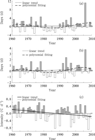
Because a daily maximum temperature ≥ 35°C can seldom be observed in Tibet and western Sichuan Basin, these areas were excluded from the research on heat wave in Southwest China. The number of hot days increased slightly (at a rate of 0.32 d per decade) in Southwest China from 1961 to 2010. On the interdecadal scale, the number of hot days from the 1960s to the mid-1970s and the mid- to late 1990s was much more than that of those years in-between. Hot days and the annual mean maximum temperature both had a significant increasing trend in the late 1990s. Especially after 2000, the annual mean maximum temperature increased significantly, and the number of hot days during the same period also increased significantly. Further statistical analysis showed that the frequency and duration of the heat waves increased while the intensity decreased slightly (Fig. 4 ), and most notably in Sichuan Basin and southern Yunnan. It was found that since the mid-1970s, under the influence of sea surface temperature increasing and the snow depth increasing in the Qinghai-Tibet Plateau in spring, the intensity of East Asian summer monsoon weakened; the West Pacific subtropical high enhanced and stretched westward with the duration extended; the meridional circulation weakened. This situation was conducive to the sustainable development of heat waves in Southwest China. Consequently, more rainfall was observed in the east part and less in the west part of Southwest China (excluding Tibet) in summer.
|
|
|
Figure 4. Anomalies of annual mean duration (a), the longest consecutive days (b), and intensity (c) of heat waves in Southwest China during 1961–2010 |
4. Precipitation
4.1. Rainfall
Both the annual rainfall (Fig. 5 a) and rainfall in flood season (Fig. 5 b) in Southwest China for the last 50 years showed a slight decreasing trend and shared a notable inter-decadal variation. In the 1960s, the 1980s and late 1990s, annual rainfall was below normal; in the 1970s and the early 1990s, annual rainfall was above normal.
|
|
|
Figure 5. Variations of annual rainfall (a), and flood season rainfall (b) in Southwest China (1961–2010) |
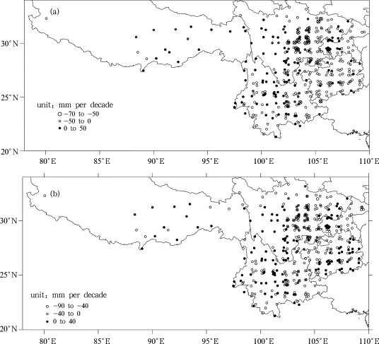
There was an obvious regional difference in the linear trends in annual rainfall (Fig. 6 a). The eastern part tended to be dry while the western part tended to be wet. The decreasing trend in north-central part of Sichuan and eastern Yunnan was rather apparent. Spatial distribution of trends in flood season rainfall (Fig. 6 b) was different from that in annual rainfall. In general, rainfall in flood season had a decreasing trend only in the mid-eastern part of Southwest China whereas it increased in the majority of other areas, especially in northeastern Sichuan Basin, western Sichuan Plateau, southeastern Guizhou and central Yunnan.
|
|
|
Figure 6. Spatial distribution of (a) annual rainfall and (b) rainfall in flood season in Southwest China (1961–2010) (cross denotes the trend significant at the 95% confidence level) |
4.2. Rainy days
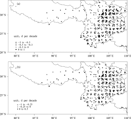
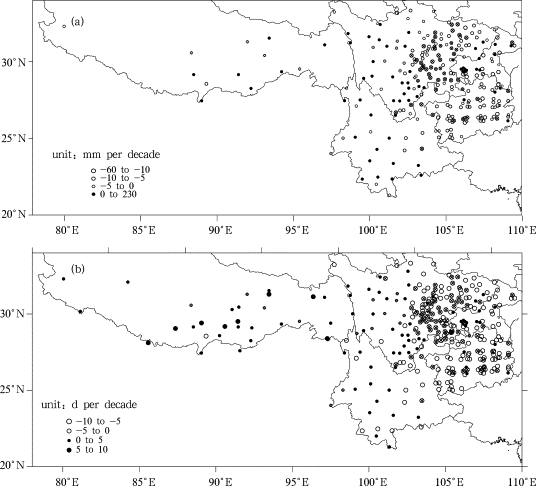
Both annual rainy days and rainy days in flood season exhibited significant decreasing trend at rates of 3.5 d per decade and 1.8 d per decade respectively during 1961–2010, and the decreasing has been much more obvious since the 1990s. The changing trend for both annual rainy days and rainy days in flood season had marked regional characteristics and was similar in spatial distribution (Fig. 7 ): while major part of Tibet and the north of western Sichuan Plateau showed increasing trend, the other region showed decreasing trend and the decrease was more remarkable in southwestern Yunnan, boarder areas of Yunnan and Guizhou, and eastern part of Sichuan Basin.
|
|
|
Figure 7. Spatial distributions of linear trends in annual rainy days (a) and rainy days in flood season (b) in Southwest China (1961–2010) (cross denotes the trend significant at the 95% confidence level) |
4.3. Extreme heavy precipitation
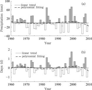
There was no obvious trend in amount and days of extreme heavy precipitation in Southwest China for the last 50 years, whereas inter-decadal variations were rather similar (Fig. 8 ). The extreme heavy precipitation percentage showed a significant increasing trend with the rate of 0.34% per decade.
|
|
|
Figure 8. Variations of extreme heavy precipitation amount (a) and days (b) in Southwest China (1961–2010) |
With regard to the spatial distribution, the amount and days of extreme heavy precipitation displayed a similar trend (Fig. 9 ): decreased in the major part of Southwest China mostly in the middle and southeast part while increased in the northwest and southwest of the region. The extreme heavy precipitation percentage increased in most of Southwest China while only decreased in the northwestern part.
|
|
|
Figure 9. Spatial distributions of linear trends in extreme heavy precipitation amount (a) and days (b) in Southwest China (1961–2010) (cross denotes the trend significant at the 95% confidence level) |
The change of rainstorm had regional differences in Southwest China. Overall, the rainstorm days in the northeastern part of Southwest China and Tibet showed a slight decreasing trend. In the central and southern part of the region, rainstorm days showed an increasing trend. As for the rainstorm intensity, the central part of Southwest China and Tibet showed a weakening trend, southern and eastern parts showed a strengthening trend.
During 1961–2010, in the majority of Southwest China, extreme light precipitation days were significantly decreasing with a rate of –4.0 d per decade. On the other hand, non-rainy days were increasing with a rate as high as 6.2 d per decade. The remarkable decrease in annual rainy days in this region was mainly the result of the decrease in light precipitation days.
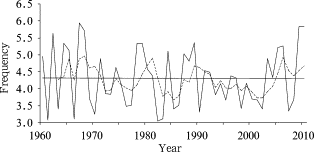
In this paper, we used the Hnmle humidity index H = P/Pe to calculate the monthly surface wetness, where P is the monthly precipitation, Pe is monthly potential evaporation; the extreme drought is defined as where the standardized H ≤–0.5 [ He et al., 2011 ]. The results showed that during 1960–2010 in Southwest China the consecutive non-rainy days also increased at the rate of 0.9 d per decade. There was apparent inter-decadal variation of extreme drought in Southwest China during the same period of time (Fig. 10 ). From the 1960s to the 1980s, the interannual variation oscillated with a period of 2–3 years. Since the 1990s, the extreme drought frequency continuously decreased.
|
|
|
Figure 10. Variations of extreme drought frequency in Southwest China during 1960–2010 [ He et al., 2011 ] |
4.4. Autumn-rain
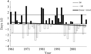
Autumn-rain is a common characteristic in Southwest China. It is characterized by localized high intensity, long duration and widespread impact, which covers the Weihe River, the Hanshui River, eastern Yunnan and eastern Sichuan. Gao [1958] pointed out that the beginning of autumn-rain was related to the advances of the jet stream over Asia and the Indian monsoon. Autumn-rain is defined as an event during which daily precipitation ≥ 0.1 mm for 5 days, and sunshine duration ≤ 0.1 h. Counted the occurrences of autumn-rain and autumn-rain days, it was discovered that the annual averaged occurrences were more than 1.8 times in 1961–2010, and average duration of autumn-rain was more than 10 d. The inter-decadal variation of autumn-rain days can be readily seen in Figure 11 . There were more in the 1960s and from the 1980s to the early 1990s, but less in the 1970s and from the late 1990s to present. Autumn-rain days showed a downward trend with fluctuations in the last 50 years [Sun et al., 2012].
|
|
|
Figure 11. Variations of autumn-rain days in Southwest China during 1961–2010 |
5. Sunshine duration, wind speed, and fog
During 1961–2010, the annual sunshine duration in Southwest China showed a statistically significant decreasing trend of –33.3 h per decade. Seasonal sunshine duration also decreased, and most noticeably in summer with a decrease rate of –18.2 h per decade (Table 3 ). There were significantly regional differences in the trend of annual sunshine duration in Southwest China. It decreased in the majority of Southwest China except for southwestern Yunnan, parts of northeastern Tibet. The spatial distribution of trends in seasonal sunshine duration was similar to that of the annual sunshine duration: mostly decreasing but with their own characteristics. In autumn, the sunshine duration increased in parts of Yunnan, Guizhou and Sichuan. In winter, the sunshine duration increased in the north of western Sichuan Plateau and in the south of mountain area of southwestern Sichuan.
| Project | Sunshine duration (h per decade) | Wind speed (m s−1 per decade) | Foggy days (d per decade) |
|---|---|---|---|
| Annual | –33.3* | –0.08* | 0.21* |
| Winter | –7.2* | –0.09* | –0.05 |
| Spring | –6.4 | –0.10* | –0.03 |
| Summer | –18.2* | –0.05* | –0.13* |
| Autumn | –1.4* | –0.07* | 0.01 |
Note:
- . denotes the trend significant at the 95% confidence level
The annual foggy days had a significant increasing trend in Southwest China in the last 50 years (Table 3 ). The foggy days increased distinctively from the 1970s to the late 1990s. The variation in foggy days did not show a good spatial coherence and had strong regional features. The foggy days increased in Sichuan Basin, especially in eastern Sichuan and the north-central Chongqing, whereas they decreased noticeably in southwestern Yunnan. There is poor correlation between foggy days and sunshine duration. The reason was the differences in regional climate caused by the special terrain conditions in Southwest China. In addition, the cloud affects sunshine more significantly.
The annual mean wind speed in Southwest China had an obvious decreasing trend in the last 50 years (Table 3 ). For the spatial distribution, the majorities of Southwest China showed decreasing trend, but different places and seasons had their own characteristics. In summer and autumn, it increased in western Yunnan and parts of western Sichuan Plateau.
6. The southwestern vortex
The southwestern vortex is a mesoscale depression system, which forms in the lower troposphere over Southwest China under the influence of special topography in the Qinghai-Tibet Plateau and particular atmospheric circulation. The southwestern vortex can cause heavy rain or torrential rain in Sichuan, the middle and lower reaches of the Yangtze River, South China and North China. It is one of the important weather systems in summer.
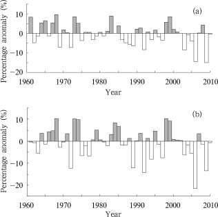
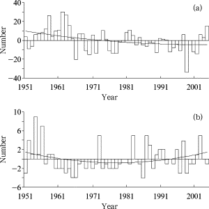
Through statistical analysis of the formation and moving of the southwestern vortex [ Li, 2009 ], it was discovered that they had decreased consistently before the 1970s. After the 1980s, frequencies of the formation still followed the decreasing trend (Fig. 12 a), whereas the number of the eastward moving vortices started to increase (Fig. 12 b).
|
|
|
Figure 12. Anomaly of the number of the formation (a), and the removal (b) of the southwestern vortex from May to September during 1951–2005 [ Li, 2009 ] |
7. Conclusions and discussion
(1) During 1961–2010, annual mean temperature in Southwest China has increased at the rate of 0.12°C per decade, most notably in the Qinghai-Tibet Plateau. Seasonal mean temperature has also shown a significant upward trend, and the most distinguished upward trend occurs in winter by 0.21°C per decade. The extreme minimum temperature has increased at a rate of almost five times as that of the extreme maximum temperature. Reduction in cold days is greater than the increase in hot days. There is asymmetric change in extreme minimum temperature and extreme maximum temperature. It is showed that annual mean temperature rising is mainly caused by the obvious rising in minimum temperature.
(2) During 1961–2010, annual precipitation and the precipitation in flood season have slightly decreased with a significant inter-decadal variability, and displayed a spatial distribution of dry in the east part and wet in the west part. Extreme heavy rainfall and days have the same inter-decadal variability. Annual rainy days and the rainy days in flood season both have decreased; the reduction of annual rainy days was caused by the reduction of light rainy days. Increase in non-rainy days and longest consecutive non-rainy days was caused by the increase of droughts.
(3) The autumn-rain in Southwest China has shown a significant inter-decadal variability. It was stronger in the 1960s and from the 1980s to the early 1990s whereas it was weaker in the 1970s and in the late 1990s. The duration of autumn-rain showed a fluctuating downward trend. During 1961–2010, the number of the formation of southwestern vortex has decreased, but the number of southwestern moving vortex has increased. The number of foggy days has shown inter-decadal variations, whereas the sunshine duration and average wind speed both have shown a significant decreasing trend.
Acknowledgements
This study was supported by the special climate change in 2010 of the China Meteorological Administration (No. ccfs-2010), and the National Natural Science Foundation of China (No. 41275097). The authors thank the National Climate Center, China Meteorological Administration and Southwestern Regional Center for Climate Change for providing the meteorological data for this study. We are very grateful to the reviewers for their constructive comments and thoughtful suggestions.
Received: 31 January 2013
References
- Alexandersson and Moberg, 1997 H. Alexandersson, A. Moberg; Homogenization of Swedish temperature data; Part I: A homogeneity test for linear trends. J. Climate, 17 (1997), pp. 25–34
- Andrew, 1987 R.S. Andrew; Testing for climate change: An applicant ion of the two-phase regression model; Journal of Climate and Applied Meteorology, 6 (1987), pp. 1401–1405
- Ding and Dai, 1994 Y.-H. Ding, X.-S. Dai; Temperature variation in China during the last 100 years; Meteorological Monthly (in Chinese), 20 (12) (1994), pp. 19–26
- Duan et al., 2000 X. Duan, W.-H. You, J.-M. Zheng; The drought and flood feature in Yunnan; Plateau Meteorology (in Chinese), 19 (1) (2000), pp. 84–90
- ECSCNARCC (Editorial Committee for Second China’s National Assessment Report on Climate Change), 2011 ECSCNARCC (Editorial Committee for Second China’s National Assessment Report on Climate Change); Second China’s National Assessment Report on Climate Change (in ChineseScience Press (2011), p. 710
- Gao, 1958 Y.-X. Gao; On the high autumn linear weather in China; Acta Mereorologica sinica (in Chinese), 29 (2) (1958), pp. 83–92
- Gong and Wang, 2012 D.-Y. Gong, S.-W. Wang; Uncertainties in the global warming studies; Earth Science Frontiers (in Chinese), 9 (2) (2012), pp. 371–376
- He et al., 2011 J.-Y. He, M.-J. Zhang, P. Wang, et al.; Climate characteristics of the extreme drought events in Southwest China during recent 50 years; Acta Geographica Sinica (in Chinese), 66 (9) (2011), pp. 1179–1190
- Hu et al., 2009 H.-R. Hu, X.-L. Mao, L. Liang; Temporal and spatial variations of extreme precipitation events of flood season over Sichuan Basin in last 50 years; Acta Geographica Sinica (in Chinese), 64 (3) (2009), pp. 278–288
- Huang, 2011 Z.-Y. Huang; Changes of dry-wet climate in the dry season in Yunnan (1961–2007); Adv. Clim. Change Res., 2 (1) (2011), pp. 49–54
- IPCC, 2007 IPCC; Climate Change 2007: The Physical Science Basis; ,in: S.D. Solomon (Ed.), et al. , Contribution of Working Group I to the Fourth Assessment Report of the Intergovernmental Panel on Climate ChangeCambridge University Press (2007), p. 996
- Jiang and Ding, 1999 Z.-H. Jiang, Y.-G. Ding; Renewed study on the warming process of Shanghai during the past 100 years; Journal of Applied Meteorology (in Chinese), 10 (2) (1999), pp. 151–159
- Li, 2009 Y. Li; The southwest vortex mobile characteristics and the impact mechanism; Nanjing University of Information Science & Technology (2009)
- Liu et al., 2006 X.-H. Liu, Z.-J. Ji, H.-B. Wu, et al.; Distribution characteristics and inter-decadal difference of daily temperature and precipitation extremes in China for latest 40 years; Journal of Tropical Meteorology (in Chinese), 22 (6) (2006), pp. 618–624
- Lund and Reeves, 2002 R. Lund, J. Reeves; Detection of undocumented change points: A revision of the two-phase regression model; J. Climate, 15 (2002), pp. 2547–2554
- Ma et al., 2006 Z.-F. Ma, J. Peng, W.-L. Gao, et al.; Climate variation of southwestern China in recent 40 years; Plateau Meteorology (in Chinese), 25 (4) (2006), pp. 633–642
- Ren et al., 2005 G.-Y. Ren, J. Guo, M.-Z. Xu, et al.; Climate changes of China’s mainland over the past half century; Acta Meteorologica Sinica (in Chinese), 63 (6) (2005), pp. 942–956
- Slonosky et al., 1999 V. Slonosky, P.D. Jones, T.D. Davies; Homogenization techniques for European monthly mean surface pressure series; J. Climate, 12 (1999), pp. 2658–2672
- Tang et al., 2005 H.-Y. Tang, P.-M. Zhai, Z.-Y. Wang; Change in mean maximum temperature, minimum temperature and diurnal range in China during 1951–2002; Climate and Environmental Research (in Chinese), 10 (4) (2005), pp. 728–735
- Wang and Zhai, 2008 X.-L. Wang, P.-M. Zhai; Changes in China’s precipitation in various categories during 1957–2004; Journal of Tropical Meteorology (in Chinese), 24 (5) (2008), pp. 459–466
- Wijngaard et al., 2003 J.B. Wijngaard, A.M.G. Klein Tank, G.P. Können; Homogeneity of the 20th century European daily temperature and precipitation series; International Journal of Climatology, 23 (6) (2003), pp. 679–692
- Xie and Cao, 1996 Z. Xie, H.-X. Cao; The asymmetric trend of change in maximum and minimum temperature in Beijing; Acta Meteorologica Sinica (in Chinese), 54 (4) (1996), pp. 501–507
- Zhai and Pan, 2003 P.-M. Zhai, X.-H. Pan; Trends in temperature extremes during 1951–1999 in China. Geophys; Res. Lett., 30 (17) (2003) 10.1029/2003GL018004
Document information
Published on 15/05/17
Submitted on 15/05/17
Licence: Other
Share this document
Keywords
claim authorship
Are you one of the authors of this document?
